Col des Annes


Contact
74450
Le Grand-Bornand
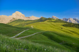
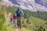
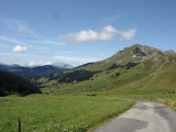
This route allows you to visit some of the Aravis’ traditional mountain chalets, some of which are still used to make cheese. The path goes through lush meadows surrounded by magnificent scenery. A cow’s life can’t be all bad!
COL DES ANNES - JUNCTION below GRAMUSSET: 1 hr 25 min
The track, which is part of the “Tournette-Aravis” long-distance footpath (GR de Pays), starts by going up through the meadows behind the farms. Be careful after rain, as the ground can be very slippery. Continue up the path to the Tête des Annes, at the top of a chairlift. The climb is steep, but the view of the narrow Confins Valley is superb.
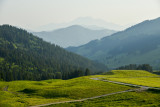
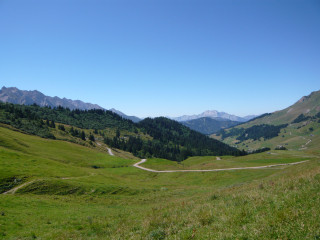
Follow the track on the left-hand side of the crest to the Col de l'Oulettaz. Do not take the dangerous path along the top of the crest. The magnificent hanging meadows on the left are in the Reposoir Valley, whose village houses a former Charterhouse. Pointe Percée (2750 m) can be seen straight ahead.
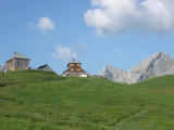
Take care crossing the limestone pavement. This section should be avoided when it is wet or foggy. Follow the GRP waymarkers. A signpost indicates the climb to the Gramusset mountain hut and the descent to the Chalet de Planet and Les Confins.
JUNCTION below GRAMUSSET - CHALET DE PLATTUY: 55 min
Go down the beautiful path to the Chalet du Planet. Smile, the marmots are watching you! After the farm at Le Planet, turn right towards the stream. Cross the stream and go down the path through the meadows on its right bank. Go below a field of willow herb and a cluster of spruce trees. The Chalet de Plattuy, with its wood-shingle roof, overlooks the valley.
CHALET DE PLATTUY - COL DES ANNES: 1 hr 15 min
Above Plattuy the path joins a wide track. Follow it leftwards for 300 m, then head up to the Col de Borneronde along a pleasant forest path lined with bilberries and raspberries. When you get to a track, turn right and go up to the pass.
Continue along the track from the Col de Borneronde back to the Col des Annes.
Option: It is possible to follow a sportier way back to the Col des Annes by turning right at the Col de Borneronde and taking the steep but very pretty path to the Tête des Annes (1 km). Turn left and go back down the outward trail to the Col des Annes.
The track, which is part of the “Tournette-Aravis” long-distance footpath (GR de Pays), starts by going up through the meadows behind the farms. Be careful after rain, as the ground can be very slippery. Continue up the path to the Tête des Annes, at the top of a chairlift. The climb is steep, but the view of the narrow Confins Valley is superb.
Follow the track on the left-hand side of the crest to the Col de l'Oulettaz. Do not take the dangerous path along the top of the crest. The magnificent hanging meadows on the left are in the Reposoir Valley, whose village houses a former Charterhouse. Pointe Percée (2750 m) can be seen straight ahead.
Take care crossing the limestone pavement. This section should be avoided when it is wet or foggy. Follow the GRP waymarkers. A signpost indicates the climb to the Gramusset mountain hut and the descent to the Chalet de Planet and Les Confins.
JUNCTION below GRAMUSSET - CHALET DE PLATTUY: 55 min
Go down the beautiful path to the Chalet du Planet. Smile, the marmots are watching you! After the farm at Le Planet, turn right towards the stream. Cross the stream and go down the path through the meadows on its right bank. Go below a field of willow herb and a cluster of spruce trees. The Chalet de Plattuy, with its wood-shingle roof, overlooks the valley.
CHALET DE PLATTUY - COL DES ANNES: 1 hr 15 min
Above Plattuy the path joins a wide track. Follow it leftwards for 300 m, then head up to the Col de Borneronde along a pleasant forest path lined with bilberries and raspberries. When you get to a track, turn right and go up to the pass.
Continue along the track from the Col de Borneronde back to the Col des Annes.
Option: It is possible to follow a sportier way back to the Col des Annes by turning right at the Col de Borneronde and taking the steep but very pretty path to the Tête des Annes (1 km). Turn left and go back down the outward trail to the Col des Annes.
From 15/04 to 31/10.
Depending on the weather.
Depending on the weather.
Description
- SITRA services :
- 800 Route
- 10.5 Distance (km)
- Levels of sporting experience :
- Level black - very hard
Localisation
FICHE_INFO_SIMPLE_LIBELLE_DESTINATION
74450
Le Grand-Bornand
GPS coordinates
Latitude : 45.94175
Longitude : 6.429126
Tarifs
Free access.
Download
View also
04 50 02 78 00
Balcony trail, offering a bucolic and panoramic atmosphere of "La Clé des Annes". Departure from Annes pass and return by Fenil farms.