La Pointe Percée : Hike and rock climbing


Contact
62 place de l'église
Le Grand-Bornand Village
74450
Le Grand-Bornand
Ascent of Pointe Percée via the normal route or via the Sallanches chimneys.
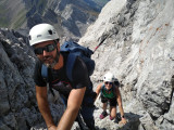
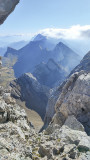
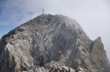
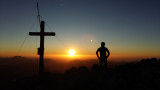
Hiking and climbing at Pointe Percée, the main summit of the Aravis range in Haute-Savoie, facing Mont Blanc.
Hiking and climbing at Pointe Percée, the main summit of the Aravis range in Haute-Savoie, facing Mont Blanc.
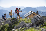
Grand-Bornand's flagship peak, Pointe Percée (2750 m) is the highest point in the Aravis mountain range. This is the gateway to the high mountains. There is no glacier, but the setting is mineral, with only a few flowers still appearing here and there. Climbing it requires a few short steps, and gradually the notion of height takes hold. This is when you realise that you have left the world of mountain pastures behind. Nevertheless, the Pointe Percée remains an accessible summit and reaching its summit is always an enchantment.
Depending on your wishes, and with our advice, we'll either take the normal route on the Grand-Bornand side or the Cheminées de Sallanches, a normal southern route that's more technical and aerial. Depending on how far the snow and snowdrifts have melted, this climb may require crampons and ice axe. Your guide will also be able to rope you in and you will have to progress at the same pace as the group.
This hike can be done in a day and a half, sleeping at the Gramusset or Doran refuges so that you can leave first thing in the morning.
Very good hiking skills required.
For more detailed information guide service office hours at the Tourism Office (Maison du Tourisme) are from 6 PM to 7 PM, in July and August.
Departure by car or car pool, for a journey of around 20 minutes to the Col des Annes, the usual starting point for the hike. Other meeting points and access on request.
From 01/07 to 31/08, every Thursday.
In summary
- Reception :
- Italian
- French
- English
- SITRA services :
- 12 yrs old min
- 4 Groups accepted
- 3 Services
- Type of activity :
- Accompanied
Description
- Climbing sports :
- Climbing sports
- Climbing
- Pedestrian sports :
- Hiking
- Pedestrian sports
Localisation
FICHE_INFO_SIMPLE_LIBELLE_DESTINATION
62 place de l'église
Le Grand-Bornand Village
74450
Le Grand-Bornand
GPS coordinates
Latitude : 45.942153
Longitude : 6.427716
Tarifs
Group package: 155 € per person
Package with private guide: 450 € for the group.
20 € per additional person (max. 4 people).
Package with private guide: 450 € for the group.
20 € per additional person (max. 4 people).
- Method of payment :
- Bank/credit card
- Cheque
- Cash
- Ch
- Credit transfer