Via Ferrata: la Tour du Jallouvre
Contact
Le Grand-Bornand Chinaillon
74450
Le Grand-Bornand
The via ferrata of the Tour du Jallouvre is characterized by an atmosphere both aerial and mineral. Difficulty range from AD to D+ depending on the chosen route.
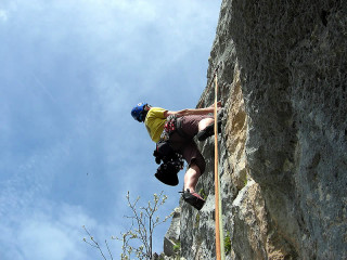
After a 20 to 30 minute approach from the parking lot, start up the first section by traversing a series of ledges up and left, over good quality rock, that lead to “Arche du Bouquetin” (Ibex Arch), just prior to the crux of the route. Climb up and over the slightly overhanging crux via a series of small steps, which require moves similar to climbing. This overhanging section is called the “Cul Tourné”, French for “turning your rear end around”. After a section over rock, then another easy section, traverse directly towards “La Tour” (TheTower).
You can stop here, and start your descent via the “Sortie à Fred” (Fred’s Exit), by walking along an easy ledge, and then down a few steps to the descent trail.
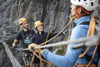
Reach the tower via a 16 m long hanging footbridge (the “Passeralle du Gypaète” or “Bearded Vulture footbridge”, there are bearded vultures in the area). Enjoy the exposure when crossing the footbridge and then start climbing up the impressive pillar overhead. A long traverse across the rocky face followed by another hanging footbridge will be an exciting experience to say the least. One more easy section up a beautiful arête and you’ve reach the top of the tower.
The descent starts via a long traverse across Jalouvre’s upper face until you reach a steep couloir equipped with cables, bringing you to Col du Rasoir pass and a well used hiking trail. (Often snow here at the beginning of the season).
DIFFICULTY: this route is fairly long and committing, especially once beyond the hanging footbridge. The descent can also be more challenging at the beginning of the season when there may still be snow.
TECHNICAL INFORMATION :
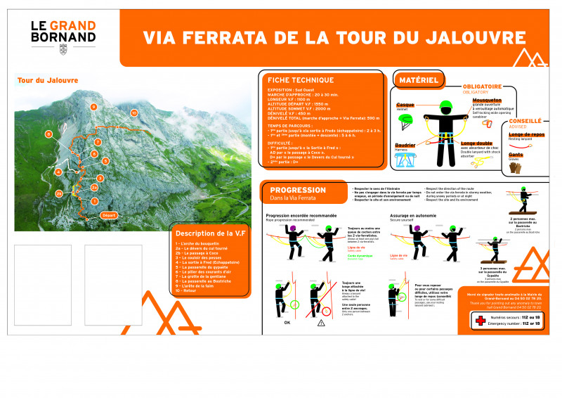
Approach walk: 20 to 30 min.
Exposure: South-West
Length : 1100 m
Vertical drop Via Ferrata : 450 m
Altitude of Via Ferrata summit : 2000 m
Alfifude departure Via Ferrata : 1550 m
Total height difference: 590 m
Total climbing time : 5 to 6 h (ascent + descent) / (in French)
Fred's outing - Time: 2 to 3 hours.
Difficulty: 1st part to "la Sortie à Fred": AD by the "passage à Coco", D+ by the passage "le Sortie à Fred". D+ by the passage "le Devers du Cul tourné", 2nd part: D+.
Two other via ferrta in the area are of interest:
- The “Yves Pollet-Villard” via ferrata in La Clusaz, just off of the road that leads to Col des Aravis pass. Difficulty: D
-The “Roche à l’Agathe” (Agatha’s Rock) in Thônes, just outside the village center. Difficulty: D and TD
3 possible routes :
- Classic route : 1100 m long, difficulty D+.
- Possibility to do only the first part by going out by the "échappatoire" : 500 m long, difficulty D+. The exit by the escape route includes a delicate section equipped with a handrail, so it is advisable to keep your equipment on you.
- Eterlou variant: AD level.
Leaflet available at the Tourist Office.
It is recommended to the hikers to be vigilant because the exit path goes along a park guarded by Patous.
From 23/05 to 02/11.
Opening subject to snow conditions. You practice under your own responsibility. Check with the Tourist Office or the Guide Bureau before you leave.
Subject to favorable weather.
Opening subject to snow conditions. You practice under your own responsibility. Check with the Tourist Office or the Guide Bureau before you leave.
Subject to favorable weather.
In summary
- Environment :
- Village 2 km away
Description
- SITRA services :
- Route BOUCLE
- 450 Route
- 1.1 Distance (km)
- Climbing sports :
- Via ferrata
- Rock climbing site
- Levels of sporting experience :
- Levels of sporting experience
- AD
Localisation
FICHE_INFO_SIMPLE_LIBELLE_DESTINATION
Le Grand-Bornand Chinaillon
74450
Le Grand-Bornand
GPS coordinates
Latitude : 45.985721
Longitude : 6.457316
From Le Grand-Bornand Chinaillon, head towards Col de la Colombière pass. Park in the obvious turnout (sign) at one of the turns prior to reaching the pass. A sign indicates the start of the approach.
Tarifs
Free access.
Download
View also
04 50 02 78 20
The Tour du Jalouvre ("Tour" means "Tower", 1988 m) is a sub-peak of the Pic du Jalouvre (2408 m), a popular summit for hikers. High-quality climbing of moderate difficulty, this southeast-facing area dries quickly, allowing early-season climbing.
06 36 21 19 10
Discover one of the 3 via ferrata ot the Aravis Mountains (in Le Grand-Bornand, La Clusaz and in Thônes) with a guide from the local Guide Company. Appointment to be defined with your guide according to the chosen route.
06 36 21 19 10
Discover one of the 3 via ferrata ot the Aravis Mountains (in Le Grand-Bornand, La Clusaz and in Thônes) with a guide from the local Guide Company in collective session. Appointment to be defined with your guide according to the chosen route.
06 36 21 19 10
Vary the pleasures and the mountain activities with this 4 half-day course combining climbing, via ferrata, canyoning and mountain biking, supervised by professional instructors.

