Tour de la Mandallaz - Cycling route


Contact
74000
Annecy
Very close to Annecy, it start as for the Tour of the Montagne d'Age. During the descent, the views over the city, the lake and ranges are epic.
POINTS OF INTEREST
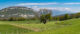
This scenic walk takes in the orchards of Cercier, a traditional fruit-growing area thanks to its good exposure, moderate altitude and soil quality. Not forgetting the bucolic atmosphere of the hills and hamlets of the Montagne de la Mandallaz and the views over Lake Annecy, the Aravis massif and the Bauges.
CYCLING ADVICE
When leaving the Annecy conurbation, avoid entering the Épagny shopping area off the cycle path.
Direction: clockwise.
Landmarks and connections: Epagny; Sillingy (separation with Tour de la Montagne d'Age n°5, Boucle du Rhône n°16 and Tour du Vuache n°17); Cercier; carrefour des Quatre-Chemins (common return with Circuit du Pont de la Caille n°7).
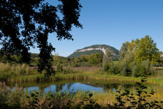
Description: La Mandallaz is a small pre-alpine massif, 8 km long and rising to 929 m above sea level, which forms a barrier to the landscape north-west of Annecy. The site of an active geological fault, it was rocked by earthquakes again a dozen years ago.
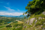
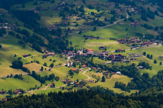
Joint start with Tour de la Montagne d'Age n°5, Boucle du Rhône n°16 and Tour du Vuache n°17: Pass through Cran-Gevrier, the Brassilly viaduct, then the villages of Gillon, Epagny and Sillingy. At the Sillingy roundabout, leave the other 3 routes and head for La Balme-de-Sillingy via "le chemin des écoliers" (a small lane reserved for children cycling to school). At the La Balme roundabout, take the flat rising RD3, then the RD203, towards Cercier. This part of the route takes you through pleasant countryside. Passing the Croix de Cercier fruit cooperative proves that local agriculture is still very much alive. After passing through the village of Cercier, you follow a very gentle slope along the side of the valley of the Grandes Usses torrent. When you reach the Quatre-Chemins crossroads, you'll find a common route with the return of Circuit n°7 from the Pont de la Caille, which is 2 km below you, so a short round trip is highly recommended to see it! After a sharp left turn at Rossy, the most spectacular part of the circuit begins: a long "descent with views". And what views they are! Annecy at the foot, the glistening lake, Parmelan, Tournette and the Bauges in the background... don't hesitate to stop at the many "photo points"!
At the end of the descent, you're in Epagny, where you'll recognize the path you took on the outward journey.
This scenic walk takes in the orchards of Cercier, a traditional fruit-growing area thanks to its good exposure, moderate altitude and soil quality. Not forgetting the bucolic atmosphere of the hills and hamlets of the Montagne de la Mandallaz and the views over Lake Annecy, the Aravis massif and the Bauges.
CYCLING ADVICE
When leaving the Annecy conurbation, avoid entering the Épagny shopping area off the cycle path.
Direction: clockwise.
Landmarks and connections: Epagny; Sillingy (separation with Tour de la Montagne d'Age n°5, Boucle du Rhône n°16 and Tour du Vuache n°17); Cercier; carrefour des Quatre-Chemins (common return with Circuit du Pont de la Caille n°7).
Description: La Mandallaz is a small pre-alpine massif, 8 km long and rising to 929 m above sea level, which forms a barrier to the landscape north-west of Annecy. The site of an active geological fault, it was rocked by earthquakes again a dozen years ago.
Joint start with Tour de la Montagne d'Age n°5, Boucle du Rhône n°16 and Tour du Vuache n°17: Pass through Cran-Gevrier, the Brassilly viaduct, then the villages of Gillon, Epagny and Sillingy. At the Sillingy roundabout, leave the other 3 routes and head for La Balme-de-Sillingy via "le chemin des écoliers" (a small lane reserved for children cycling to school). At the La Balme roundabout, take the flat rising RD3, then the RD203, towards Cercier. This part of the route takes you through pleasant countryside. Passing the Croix de Cercier fruit cooperative proves that local agriculture is still very much alive. After passing through the village of Cercier, you follow a very gentle slope along the side of the valley of the Grandes Usses torrent. When you reach the Quatre-Chemins crossroads, you'll find a common route with the return of Circuit n°7 from the Pont de la Caille, which is 2 km below you, so a short round trip is highly recommended to see it! After a sharp left turn at Rossy, the most spectacular part of the circuit begins: a long "descent with views". And what views they are! Annecy at the foot, the glistening lake, Parmelan, Tournette and the Bauges in the background... don't hesitate to stop at the many "photo points"!
At the end of the descent, you're in Epagny, where you'll recognize the path you took on the outward journey.
All year round.
Subject to favorable snow and weather conditions.
Subject to favorable snow and weather conditions.
Description
- SITRA services :
- Route BOUCLE
- 580 Route
- 55 Distance (km)
- Levels of sporting experience :
- Level bue - easy
Localisation
FICHE_INFO_SIMPLE_LIBELLE_DESTINATION
74000
Annecy
GPS coordinates
Latitude : 45.901541
Longitude : 6.129357
Car Park: Préfecture
Tarifs
Free access.
View also

04 50 45 00 33
You can do it! The signposted direction was chosen to make the only climb on the circuit as easy as possible and to allow you to stay close to the lake, especially for the section after Talloires.
04 50 45 00 33
One of the area's great classics, with a beautiful descent between Serraval and St-Ferréol, and an easy return leg along the Annecy Cycleway.

04 50 45 00 33
If you hate steep climbs, this is not the ride for you. Great view overlooking the lake.
04 50 45 00 33
An easy tour to see the hidden-side of this little mountain from Annecy.