The Border Stone


Contact
au pied de la combe de Tardevant sur le chemin de
74450
Le Grand-Bornand
Phone : +33 4 50 02 79 18
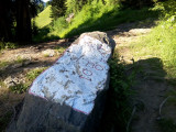
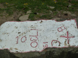
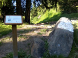
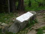
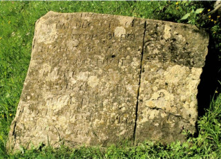
The inscribed border stone, at the foot of the dale of Tardevant, marks the limit between the villages of Le Grand Bornand and La Clusaz. This stone is about 1m. long and is dated 1755.
The inscription of the stone marked the end of a border conflict that lasted almost 300 years.
This limestone boulder is an erratic, left behind by a glacier during the Würm glaciation (Quaternary period). The stone has two holes in it, linked by a short channel. Archaelogical investigation suggests that the stone was used for ancient rites.
In the XVth century, a disagreement on grazing rights broke out between the villages of Le Grand Bornand and La Clusaz concerning the pastures of the Aravis dales, particularly those of the Tardevant. Towards the end of the Middle Ages, the conflicts occured often as there were no clear natural boundaries, such as a stream or a hill crest.
In 1477, this conflict was temporarily resolved by a commision appointed by Janus, the Duke of Savoie. However, the disagreement only really ended in 1755, with the inscription of a cross on a long piece of limestone rock at the foot of the dale below the Tardevant. The stone is on the path linking the Paccaly valley to the Bombardellaz pastures.
This stone still represents the border between the two villages and has done so ever since the Sardinian maps were drawn up, the first European land-ownership maps. The map-making process for the Savoie estates took place between 1728 and 1738, so the map concerning Le Grand Bornand was drawn up during this time.
From 01/05 to 30/11 : open daily.
Description
- Period :
- 18th C
- Historical heritage :
- Historic patrimony
- Statue
Facilities and services
- Parking :
- Parking
- SITRA services :
- Services
- Services
- Services
- Services
- Services
- Services
To note
- Type of SITRA offer :
- Not recommended in bad weather
- Open air
Localisation
FICHE_INFO_SIMPLE_LIBELLE_DESTINATION
Pierre marquée
au pied de la combe de Tardevant sur le chemin de
74450
Le Grand-Bornand
GPS coordinates
Latitude : 45.934858
Longitude : 6.50381
Tarifs
Free
View also
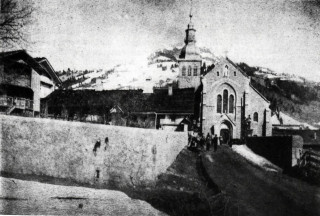
After 60 years of building work, undertaken and financed by the local community,it was consecrated in 1877. Built in the neo-gothic style of the XIX century, the architecture is typical of the golden age of the Catholic church.
The chapel of Le Bouchet, in the heart of the Bouchet valley, was founded in 1704 after a flood. It boasts a beautiful altarpiece, dating back to the XVIII century.
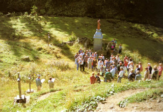
The Stations of the Cross pilgrimage at La Duche originated in 1888, linking the chapel of La Duche with St Bruno's oratory, the site of a miraculous spring.
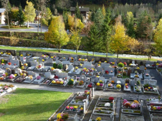
The original cemetery was situated for a long time immediately around the church. In the mid-XX century, it had to be relocated so that a new village square could be built in front of the Tourist Office, the Town Hall and the church.
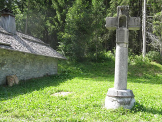
The cross at Le Clos du Pin is unusual for two reasons : firstly, this stone cross is the oldest of all the Le Grand Bornand crosses (dating from 1500) and secondly, and for the same reason, it has been classified since 1944 as a heritage monument.
The Town Hall is a stone building, typical of early XX century architecture. It houses all the municipal services and the meeting room for the village council.
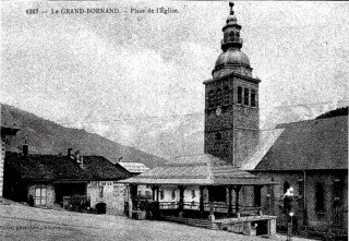
The weekly market at the Grenette, the old grain market of Le Grand Bornand, characterizes the heart of the old town square. All sorts of concerts and events also take place here, such as concerts given by the local brass band and many local celebrations.
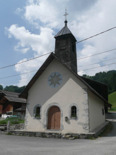
The chapel of la Duche is the oldest of Grand Bornand. Based in the end of the XVIIth century,it is reconstructed at the end of the XIXth century. Itis dedicated in particular to several agrarian saints: saint Anne, saint Grat and saint Guérin.
Founded in 1677, the chapel is nestled in the heart of the old village of Le Chinaillon. Despite major renovation work to the building in 1977, it has retained its traditional appearance.
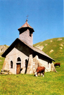
Located in the heart of the hamlet of Les Plans, the chapel of the same name was founded in 1702 after the flooding of the Borne river. From the chapel there is a wonderful view over the Aravis mountain chain.
Standing above the village of Le Grand Bornand, with panoramic views over the Aravis chain, the chapel of Le Nant Robert is well worth seeing. It was founded in 1762 and renovated on several occasions during the course of the XX century.
At the end of the Bouchet valley, just above the hamlet of Lormay, there is a stone testifying to events which took place during the French Revolution : priests refusing to swear allegiance to the Constitution were hidden by the local population.
04 50 02 78 00
During your walks, use your mobile phone to discover in an interactive way all the richness of Le Grand-Bornand.